Where to stay in San Francisco
Find the best neighborhoods and hotels in San Francisco.
Open page →
Plan your trip to San Francisco with a structure that respects the city’s hills, fog, waterfront exposure, and sharply different neighborhoods. This guide helps you understand where to stay, how to group your days, which experiences genuinely explain the city, and how to avoid the classic mistake of treating San Francisco like a flat checklist. Once the city is read through elevation, bay light, Pacific weather, and district rhythm, it becomes far easier to plan — and much more rewarding to explore.
Find the best neighborhoods and hotels in San Francisco.
Open page →
Prioritize the activities that deserve your time in San Francisco.
Open page →
2 Days in San Francisco: First-Time Itinerary
Open itinerary →
3 Days in San Francisco: Walkable First-Time Itinerary
Open itinerary →
4 Days in San Francisco: Neighborhood-Led Itinerary
Open itinerary →
7 Days in San Francisco: Complete Week Itinerary
Open itinerary →
San Francisco is a compact major city whose real scale is shaped by topography, water, weather, and neighborhood identity rather than mileage. Hills turn short distances into meaningful movement decisions; the bay and Pacific alter light, wind, and temperature within the same day; and districts such as North Beach, Chinatown, the Mission, the Marina, the Presidio, and Golden Gate Park each function as distinct travel territories. The city rewards travelers who plan by zone, elevation, and energy level instead of trying to connect every famous sight in a single loop.
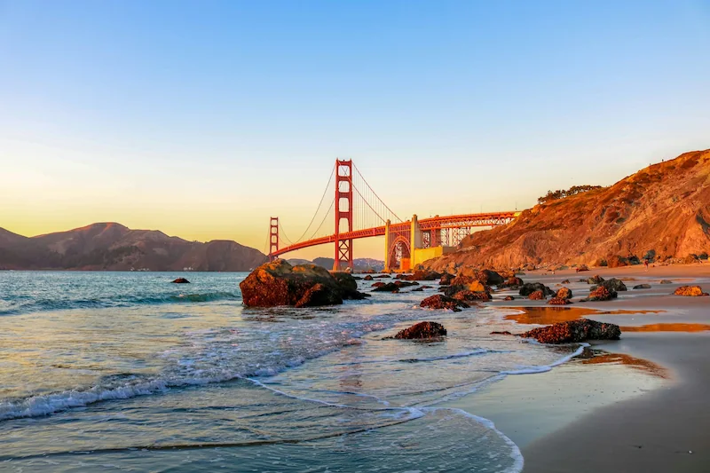
San Francisco compresses bridge drama, island history, Victorian streets, immigrant neighborhoods, public gardens, coastal trails, food culture, and civic-scale views into a surprisingly small footprint. Its appeal is not only the Golden Gate Bridge or Alcatraz; it is the way fog moves through the strait, how a steep street suddenly opens to the bay, how Chinatown and North Beach change the rhythm of an evening, and how the western edge of the city feels closer to the Pacific than to downtown. At its best, San Francisco feels curated by geography rather than tourism.
Best time: September to early November for the clearest skies, strongest views, and most reliable walking conditions.
Ideal trip length: 3 to 4 days for a strong first visit; 5 days if you want Golden Gate Park, the Presidio, coastal edges, museums, and one relaxed bay-area extension.
San Francisco is expensive, but the biggest planning cost is often not a single attraction — it is poor location logic. A badly chosen base creates repeated ride-hailing, long cross-city transfers, weaker evenings, and more fatigue on hills. Accommodation usually drives the budget first, followed by booked anchors such as Alcatraz, museums, bike rentals, food tours, and day trips. The smartest value comes from paying for the experiences that clarify the city — Alcatraz, one major museum or science stop, a bike/ferry sequence, or a guided food walk — while letting parks, viewpoints, waterfronts, and neighborhoods carry much of the trip for free.
San Francisco is organized by elevation, water, and district rhythm. Hills fracture the grid into micro-territories, the bay pulls visitor movement toward the north and east, and the Pacific gives the west side a cooler, more exposed mood. This means a good itinerary is not simply a sequence of nearby pins: it is a controlled movement between high viewpoints, waterfront edges, parkland, and neighborhoods where food and street life make the city legible.
The city sits at the tip of a peninsula, with the Pacific Ocean on the west, San Francisco Bay on the east, and the Golden Gate opening to the north. The northern waterfront contains many first-trip anchors; the central hills create classic street drama; Golden Gate Park stretches across the western half; the Presidio protects the city’s most scenic bridge-facing edge; and the Mission, Castro, Hayes Valley, Japantown, Chinatown, and North Beach provide the urban texture that prevents a trip from becoming only viewpoints and icons.
Clearer mornings are the best time for bridge walks, Twin Peaks, ferry movement, Lands End, or other open-air views. Midday works well for Golden Gate Park, museums, Chinatown, the Ferry Building, or the Mission. Afternoons often bring wind or fog near the Golden Gate and western edge, while evenings narrow into dinner districts and performance corridors. The city is not uniformly lively at night, so evening planning should be neighborhood-specific rather than improvised from wherever the day ends.
Think in territories, not attractions. A strong day might be Alcatraz plus the Embarcadero and North Beach; the Golden Gate Bridge plus Crissy Field, Tunnel Tops, and the Presidio; or Golden Gate Park plus the Inner Sunset. Avoid crossing the city repeatedly for symbolic variety. San Francisco becomes clearer when each day has one anchor, one walking territory, and one natural food or evening landing point.
Open the planner
Build each day around one geographic territory and let adjacent stops layer naturally onto it. Use the clearest morning window for Golden Gate Bridge, Twin Peaks, Lands End, ferry rides, or other weather-sensitive views. Treat hills as itinerary design, not background scenery; repeated climbs can quietly drain a day even when the map looks compact. Reserve Alcatraz early, then shape the rest of that day around the northern waterfront, Ferry Building, Chinatown, or North Beach. Use Golden Gate Park, the Presidio, and the western coast as half-day territories rather than quick add-ons between central neighborhoods. Let the Mission, Chinatown plus North Beach, Hayes Valley, Japantown, or the Marina carry an evening instead of relocating late only for variety. Use transit and rideshare selectively for topographic resets, but preserve walking for the district that actually rewards close reading. Keep Fisherman’s Wharf short unless children, sea lions, Alcatraz logistics, or a bay cruise make the area useful. On longer stays, widen toward Castro history, Lands End, Legion of Honor, Outer Richmond, Ocean Beach, Sausalito, or Muir Woods only after the core city logic is clear.
Vibe: Human-scale, historic, café-led, and unusually easy to use at the end of a day.
Why go: Dense yet navigable, with dining, Coit Tower, Chinatown, the waterfront, and cable-car logic all within reach.
Who it fits: First-timers, couples, food-led travelers, and anyone who wants evenings to unfold without a long transfer.
Not for: Visitors seeking very quiet nights, large resort-style hotels, or the lowest possible room rates.
Where to stay: One of San Francisco’s most efficient bases: central enough for first-trip structure, atmospheric enough to avoid a purely business-district feel.
Vibe: Composed residential grandeur overlooking the bay.
Why go: Architectural continuity, bay-facing views, calmer nights, and access toward the Marina, Fillmore, Japantown, and Presidio edge.
Who it fits: Couples, design-aware travelers, repeat visitors, and comfort-led stays that value residential elegance.
Not for: Travelers who want immediate access to late-night energy, major transit hubs, or budget-heavy lodging.
Where to stay: A refined, calmer base that works best when elegance and quieter evenings matter more than instant landmark access.
Vibe: Sunlit, expressive, and decisively culinary.
Why go: Murals, taquerias, independent retail, cafés, Dolores Park edges, and one of the city’s strongest food-and-street-life corridors.
Who it fits: Food-first travelers, repeat visitors, younger couples, and anyone who wants San Francisco to feel lived-in rather than polished.
Not for: Travelers prioritizing quiet, classic postcard views, or the most convenient first-time hotel logistics.
Where to stay: Better as a strong activity and dining district than as the universal first-trip base, but essential for understanding the city beyond the waterfront.
Vibe: Historic altitude with legacy hotels and cinematic gradients.
Why go: Cable cars, historic hotels, central hill drama, Chinatown access, and a strong sense of classic San Francisco verticality.
Who it fits: Short stays, first-timers who want old-city atmosphere, and travelers who like iconic streetscapes.
Not for: Anyone who dislikes steep walks or wants the easiest late-night return after dinner.
Where to stay: A classic high-ground base with strong orientation value, as long as you accept the physical reality of ending days uphill.
Vibe: Compact, polished, quietly design-forward.
Why go: Restaurants, cafés, boutiques, Civic Center and performing-arts access, and a compact layout that reduces planning friction.
Who it fits: Design-minded travelers, couples, culture-led stays, and visitors who prefer curated but not over-touristed evenings.
Not for: Travelers who want bridge views, waterfront air, or the most historic first-trip atmosphere outside the door.
Where to stay: A polished and practical base for structured stays, especially if dining, performances, and central access matter.
Vibe: Open waterfront energy with rare flat walking routes.
Why go: Flat walking, bay views, Palace of Fine Arts, Crissy Field, Golden Gate approaches, and access to the Presidio.
Who it fits: Families, runners, walkers, bridge-focused first-timers, and travelers who want more open air than central density.
Not for: Visitors who need rapid access to downtown museums, BART corridors, or the Mission.
Where to stay: Scenic and breathable, but best for travelers who are comfortable planning transport back to central and southern neighborhoods.
Vibe: Dense, historic, sensory, and highly readable on foot.
Why go: Compact cultural density, food stops, historic alleys, North Beach adjacency, Nob Hill access, and classic first-trip atmosphere.
Who it fits: Travelers who want heritage, walkability, daytime food stops, and a strong city texture outside the hotel door.
Not for: Visitors who want spacious hotel infrastructure, car convenience, or quiet residential calm.
Where to stay: A strong cultural core when you want the city to feel immediate, layered, and walkable from the first morning.
San Francisco is best understood through a few clear experience layers: the bay and bridge, the steep city, the parks and Presidio, the immigrant and countercultural neighborhoods, the museums, and the Pacific-facing western edge. The goal is not to turn every attraction into a must-do, but to choose the experiences that explain how the city works.
Planning tip: Use open-air, view-dependent experiences in the clearest part of the day, then shift into museums, gardens, food corridors, or neighborhood walks when wind, fog, or fatigue start to matter.
Walking the span reveals the bridge as infrastructure, weather machine, viewpoint, and movement corridor at once. It is far more meaningful when paired with Crissy Field, Fort Point, Tunnel Tops, or the Presidio rather than treated as a quick photo stop.
Tip: Start early, dress for wind, and decide in advance whether you are walking part of the span or crossing the full bridge.
Alcatraz remains the city’s strongest single booked attraction because the boat ride, island setting, prison story, and bay views combine into one coherent experience.
Tip: Book early and build the rest of the day around the waterfront rather than crossing the city repeatedly afterward.
A bay sail or cruise gives a different reading of San Francisco: skyline, island, bridge, headlands, and weather all become spatially connected from water level.
Tip: Choose it when you want the bay itself to be part of the trip, not only a backdrop.
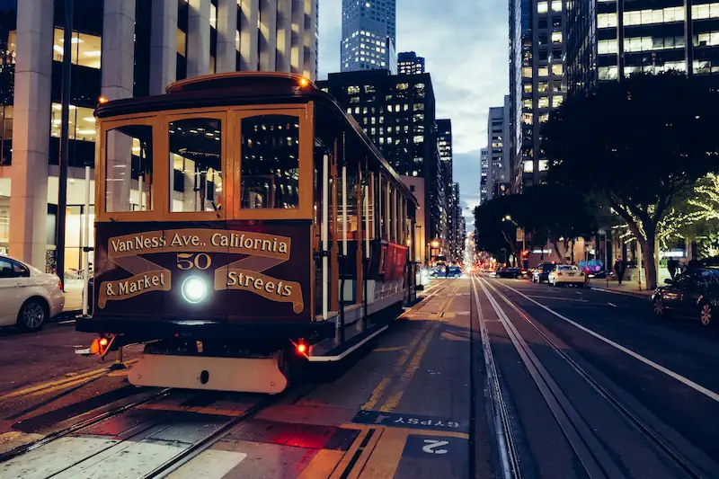
The cable car is worth doing once because it explains the city’s steep transport logic, but it should stay a short atmospheric ride rather than a queue-dominated day anchor.
Tip: Board away from the busiest terminals when possible, or pair the ride with Nob Hill and the Cable Car Museum.
Weather becomes visible architecture as marine layers pour inland.
Tip: Late summer afternoons often produce the strongest effect.
Check guided tours →
Twin Peaks gives one of the cleanest reads of San Francisco as a peninsula city, but only when visibility is good. It is valuable because it explains the relationship between downtown, hills, bay, and western neighborhoods in one sweep.
Tip: Check visibility before going; it is not worth forcing in heavy fog.
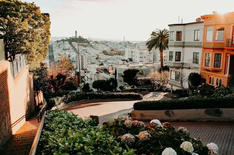
Quiet conditions transform the curves into landscape design.
Tip: Arrive before 8am for clarity.
Check guided tours →
The monument works best as part of a Marina or Presidio sequence rather than as an isolated stop.
Tip: Pair it with Crissy Field or a Marina walk instead of treating it as a stand-alone outing.
Check guided tours →
Pier 39 is crowded and commercial, but the sea lions, bay setting, and easy family appeal make it useful in small doses. Its best role is a short stop attached to Alcatraz, the northern waterfront, or a child-friendly morning.
Tip: Use it briefly as part of a north waterfront route, not as a stand-alone anchor.
Check guided tours →
Tunnel Tops is now one of the most useful open-air anchors in the city: bridge views, lawns, family space, food-truck potential, and Presidio access all in one manageable setting.
Tip: Start at the visitor center, then link Tunnel Tops with Crissy Field, the Main Post, or a bridge-facing walk.
Check guided tours →
The building channels movement upward using controlled light.
Tip: Midweek afternoons offer the most breathing room.
The Academy is the most efficient indoor anchor in Golden Gate Park because it works for mixed ages, mixed weather, and travelers who want one substantial stop rather than several smaller exhibits.
Tip: Give it real time — it works best as a major half-day, not as a quick park add-on.
The Japanese Tea Garden gives Golden Gate Park a more composed and atmospheric register than the big museums, making it useful when the day needs calm rather than scale.
Tip: Best paired with one other selected park stop rather than a full museum stack.
Check guided tours →
The Botanical Garden is a slower way to understand San Francisco’s climate and park culture, especially when you want a gentler counterweight to waterfront wind and viewpoint pressure.
Tip: Works best on a clearer, less rushed day when you want the park to breathe.
Check guided tours →
Victorian repetition foregrounding modern density captures the city’s visual duality.
Tip: Stand higher in Alamo Square for cleaner alignment.
Two centuries of engineering intersect within a single sightline.
Tip: Check hours — closures occur.
Check guided tours →
Markets and delivery flows reveal the district’s logistical backbone.
Tip: Visit mid-morning when vendors are fully active.
The Castro adds a civic and cultural layer that the classic bridge-and-bay itinerary can miss. It is best treated as a compact neighborhood walk or evening extension, especially for travelers who want San Francisco’s identity to feel broader than landmarks.
Tip: Use it with the F-line, Mission Dolores, or Hayes Valley rather than isolating it as a distant detour.
One of the cleanest ways to understand why San Francisco moves the way it does, not just how it looks.
Tip: Best paired with Nob Hill, Chinatown, or a real cable-car ride.
Check guided tours →
This pairing gives San Francisco a quieter, more European-feeling cultural edge while connecting naturally to Lands End, the Richmond, and the Pacific side of the city.
Tip: Best for a longer stay or a culture-led west-side day, not for a rushed first afternoon.
Check guided tours →
Independent cafés function as neighborhood anchors.
Tip: Weekday mornings reflect local rhythm best.
Check guided tours →
A useful counterpoint to the waterfront and central hills: quieter, culturally distinct, and easy to fold into a slower day.
Tip: Best used for a calm lunch or mid-afternoon break rather than as a rushed box-checking stop.
Check guided tours →
Haight-Ashbury works when it is read as a living neighborhood with cultural memory, vintage retail, and Golden Gate Park proximity, not as a frozen sixties postcard.
Tip: Pair it with Alamo Square or Golden Gate Park edges, not with an overloaded downtown day.
Check guided tours →
A wide atmospheric counterpoint to dense eastern districts.
Tip: Temperatures drop quickly after sunset.
Check guided tours →
The western edge changes the emotional register of San Francisco: less polished, more exposed, and far more connected to the Pacific. It is one of the best ways to widen a trip after the core icons are covered.
Tip: Pair it with the Legion of Honor, Outer Richmond, or Ocean Beach rather than a central-city sightseeing day.
Check guided tours →
Commuter patterns display regional movement logic.
Tip: Saturday markets amplify energy.
Check guided tours →
The Presidio’s trails give the city a greener, quieter structure that makes sense after the bridge or Tunnel Tops, especially when you need distance from denser streets.
Tip: Download trail maps — signage is understated.
Check guided tours →
A useful reminder that San Francisco’s best spaces are not all historic or nostalgic; some are contemporary public infrastructure done unusually well.
Tip: Best on a day with enough time to linger rather than rush through to another district.
Check guided tours →
The Mission burrito is not just a famous food item; it is a practical way to make the neighborhood part of the day through casual, comparative eating.
Tip: Queues move faster than expected.
Cold-water clarity matched with maritime air.
Tip: Arrive before peak lunch.
The Ferry Building is useful because it can be breakfast, a tasting corridor, a market stop, or a light lunch without forcing the day into a formal restaurant plan.
Tip: Use it before or after an Embarcadero walk, ferry ride, or Alcatraz day.
Dim sum or dumplings turn Chinatown into a flexible daytime route rather than a gate-and-photo stop, especially when paired with North Beach.
Tip: Follow multigenerational local crowds.
Check food options →
The district works because the food experience matches the street scale and the evening mood.
Tip: Best after a Chinatown or waterfront day rather than as a cross-city late move.
Check food options →
Japantown widens the food map with a calmer pace, easy indoor breaks, and a different cultural-commercial rhythm from the Mission or waterfront.
Tip: Works best on a slower day when you want lunch to feel like part of a neighborhood read.
Check food options →
In San Francisco, good prioritization means choosing the experiences that explain the city’s structure before adding extra famous stops. The bridge, bay, hills, parks, food corridors, and neighborhood evenings all matter, but they should not be stacked without geographic logic.
San Francisco can work very well with children when the trip is built around movement variety: cable cars, ferries, bridge views, parks, hands-on museums, open lawns, and short food stops. The city becomes harder when days rely on repeated hill climbs, long queues, or too many cross-town transfers. The best family plans usually combine one clear anchor — California Academy of Sciences, Exploratorium, Alcatraz with older kids, Tunnel Tops, or a bay ride — with room to reset at Crissy Field, Golden Gate Park, the Marina, or the Presidio.
The strongest San Francisco itineraries protect geographic discipline first. With more time, the city should not become a longer checklist; it should open outward into Golden Gate Park, the Presidio, Castro history, western coastal edges, and a carefully chosen bay or regional extension.
Open the planner →
Operational awareness matters in San Francisco because the city’s friction is rarely obvious from a map. Terrain, microclimates, car logistics, reservation timing, and evening neighborhood choice can reshape a day more than distance alone.
September through early November is usually the strongest period because visibility improves, wind often softens, and the city’s outdoor logic becomes easier to use. Spring can be lively and very workable, but clear viewpoint days are less dependable. Midsummer often surprises visitors with fog, wind, and cooler temperatures around the bridge and western edge. Winter can suit museum-led, food-led, and quieter neighborhood trips, but rain and shorter daylight make open-air planning more tactical.
Three full days can cover the essentials if you plan tightly: one bridge or bay anchor, one strong neighborhood sequence, and one museum or park territory. Four days is better for a first visit because it gives room for Alcatraz, Golden Gate Park, the Presidio, the Mission, Chinatown, North Beach, and weather flexibility. Five days allows the city to breathe and makes space for Lands End, the Castro, Japantown, or a day trip.
Choose a base that protects mornings and evenings, not just one that looks central. North Beach, Nob Hill, Chinatown, Hayes Valley, Pacific Heights, the Marina, and the Mission each solve a different version of the trip. A good base should reduce unnecessary hills at the end of the day, keep dinner options practical, and make your first two territories easy to reach. A poor base can make San Francisco feel more fragmented, expensive, and tiring than it needs to be.
Most international and long-haul visitors arrive through SFO, with Oakland also useful depending on route, fare, and final neighborhood. BART can be efficient for downtown-adjacent arrivals, but the final leg matters: North Beach, Pacific Heights, the Marina, and some residential districts may still need rideshare or local transit. Late arrivals should prioritize a simple transfer over theoretical savings, because a complicated first evening can distort the next day.
Use walking for the district you are actually exploring, transit for longer linear moves, and rideshare for topographic resets or late returns. Muni, historic streetcars, BART, ferries, bikes, and rideshare each solve different problems; none solves every day alone. Avoid renting a car for in-city sightseeing unless your plan includes regional travel, because parking, theft risk, traffic, and steep-street stress usually outweigh convenience.
San Francisco has strong medical access and straightforward visitor infrastructure, but practical awareness matters. The most relevant issues are vehicle break-ins, visible street-level distress in some blocks, wind exposure, and rapid temperature shifts. Do not leave anything visible in a parked car, avoid designing late walks through uncomfortable blocks when an easy ride would solve the issue, and carry layers even when the day starts sunny.
San Francisco’s best season is not the simple summer default many travelers expect. The city is shaped by marine weather: fog, wind, and sharp neighborhood temperature shifts can matter more than the calendar. Early fall is usually the most reliable period for first-time visitors because the bridge, bay, hills, and coastal edges read clearly. Spring works well for active neighborhood travel. Summer is lively but often foggier and cooler near the Golden Gate and Pacific. Winter can be rewarding for museums, food, and quieter streets, but open-air days need more flexibility.
Spring is a good season for travelers who want active neighborhoods, fresh park energy, and moderate crowds. It suits Mission walks, Chinatown and North Beach, Ferry Building mornings, and museum-plus-neighborhood days. The trade-off is visibility: bridge, Twin Peaks, and coastal views can be excellent, but they should not be the only reason for choosing spring.
Summer is often cooler, windier, and foggier than visitors imagine, especially around the Golden Gate, Ocean Beach, and western neighborhoods. It can still be a strong time for food, families, museums, and neighborhood-led travel, but do not plan it as a guaranteed clear-sky viewpoint season. Layers matter more in July than many travelers expect.
Autumn, especially September and October, is usually San Francisco’s best all-around period. Views are clearer, wind is often easier, outdoor movement feels more reliable, and the city’s relationship between hills, bay, bridge, and parks becomes easier to understand. For a first trip, this is the most forgiving season.
Winter suits travelers who are comfortable with rain risk, moodier light, and a quieter version of the city. It can be excellent for SFMOMA, the Academy, the Exploratorium, Chinatown meals, North Beach evenings, and lower-pressure neighborhoods. Viewpoint-heavy plans need more flexibility, but clear winter days can be beautiful.
These are the planning decisions that usually determine whether San Francisco feels elegant, tiring, expensive, or unexpectedly easy to read.
Three full days can cover the strongest first-trip essentials, but four days is a better target if you want Alcatraz, the Golden Gate Bridge, Golden Gate Park, the Mission, Chinatown, North Beach, and the Presidio without rushing. Five days is ideal if you also want Lands End, the Castro, Japantown, a major museum, and one bay-area extension.
North Beach is one of the strongest first-trip bases because it combines dining, atmosphere, waterfront proximity, Chinatown access, and easy evening logic. Nob Hill, Chinatown, Hayes Valley, the Marina, Pacific Heights, and the Mission can also work, but each fits a different travel style.
Union Square can be practical for transport, shopping, and certain hotel deals, but it is not the most atmospheric base for many leisure travelers. If the goal is neighborhood texture, evenings, food, and a more distinctive San Francisco feel, North Beach, Hayes Valley, Nob Hill, Chinatown, Pacific Heights, the Marina, or the Mission often provide a stronger trip.
Yes, and most visitors should. Walking, transit, ferries, bikes, and selective rideshare usually work better inside the city than driving. A car becomes useful mainly for regional trips such as Muir Woods, Point Reyes, Half Moon Bay, Napa, Sonoma, or Monterey.
Prioritize one Golden Gate Bridge experience, one bay-based anchor such as Alcatraz or a ferry ride, one strong neighborhood sequence, one park or viewpoint, and one food-led district. That mix gives you the iconic city and the lived-in city without turning the trip into a checklist.
Yes, especially on a first visit. It combines a ferry ride, island setting, history, and bay views in a way few San Francisco attractions can match. Book ahead and build the day around the northern waterfront rather than treating it as a small add-on.
Fisherman’s Wharf is useful in small doses, especially for kids, sea lions at Pier 39, bay cruises, or Alcatraz logistics. It is less successful as a full-day base for understanding the city. Treat it as a short waterfront segment, then move toward the Ferry Building, North Beach, the Presidio, or Chinatown.
Yes, if you give it enough time. It is a major territory with the California Academy of Sciences, de Young, Japanese Tea Garden, Botanical Garden, lakes, lawns, and western-edge access. It works poorly as a quick stop between central neighborhoods.
Twin Peaks gives one of the clearest citywide reads in good visibility, while Crissy Field, Fort Point, Tunnel Tops, and Battery-area viewpoints are better for Golden Gate Bridge context. Lands End offers a more rugged Pacific-facing view. The best choice depends on weather and where your day is already focused.
September through early November is usually the strongest period for clear skies, softer wind, and reliable open-air days. Spring can be very good for neighborhoods and parks. Summer is often foggier and cooler than expected, especially near the bridge and coast.
Do not force viewpoint-heavy plans in thick fog. Shift toward the Mission, Chinatown, North Beach, Ferry Building, SFMOMA, the Exploratorium, California Academy of Sciences, Japantown, or a food-led route. Save the bridge, Twin Peaks, Lands End, or open Presidio views for a clearer window.
Yes. The Mission is one of the best districts for murals, casual food, cafés, independent shops, and local texture. It is especially useful when a trip has become too waterfront- or landmark-heavy.
The Castro is worth adding when you want San Francisco’s civic and LGBTQ+ history to be part of the trip. It is not always a first-day priority, but it adds an important cultural layer and pairs well with Mission Dolores, the Mission, Hayes Valley, or a performance-led evening.
Yes, especially if you want bridge views, open-air movement, Tunnel Tops, Crissy Field, trails, and a calmer version of the city. It works best as a half-day territory rather than a quick bridge-view detour.
North Beach is the easiest classic evening district, while the Mission is stronger for a more local food-and-bar rhythm. Hayes Valley works well for restaurants and performances, Japantown for a calmer meal, and the Marina for a lighter waterfront-adjacent night.
Yes, if the itinerary avoids too many hills and transfers. The California Academy of Sciences, Exploratorium, Pier 39 sea lions, cable cars, bay ferries, Tunnel Tops, Crissy Field, Golden Gate Park, and Palace of Fine Arts all work well for families.
The most common mistakes are underestimating hills, packing for warm California weather, booking Alcatraz late, overloading one day with distant districts, spending too much time in Fisherman’s Wharf or Union Square, and using a car inside the city when it creates more friction than freedom.
SFMOMA is the strongest adults-first art anchor, the California Academy of Sciences is the most efficient family and rainy-day anchor, and the Exploratorium is best for hands-on science and waterfront pairing. The de Young, Asian Art Museum, Legion of Honor, and Walt Disney Family Museum are better when they fit your route or interests.
Day trips are worthwhile after you have covered the city’s core structure. Muir Woods and Sausalito are the easiest nature-and-bay extension, Napa or Sonoma suit wine-focused travelers, and Monterey, Carmel, Point Reyes, or Half Moon Bay are better with more time or a car.
Plan by territory. Put Alcatraz with the waterfront, Chinatown, or North Beach; put the bridge with Crissy Field, Fort Point, Tunnel Tops, or the Presidio; put Golden Gate Park with the Inner Sunset or west-side stops; and keep the Mission as its own food-and-neighborhood block.
Respect the hills, weather, bay logic, and neighborhood rhythm, and San Francisco becomes much easier to plan — and far more memorable to experience.
Find the best places to stay, how to get there, and move around with ease.
Build a smarter trip base
Once you understand how San Francisco works and what matters most for your trip, the next step is turning that direction into a real itinerary. Use the planner to organize your days around the right areas, experiences, and rhythm so the trip feels clear before you go.